-
Program:
Urbanization
-
Status:
Under construction
-
Area:
515 hectares.
- Awards:
-
This project is located in Colonia, on a lot along the river. It consists of various hotel, housing and commercial components that complement each other and coexist to enhance the unique characteristics of the surrounding landscape.


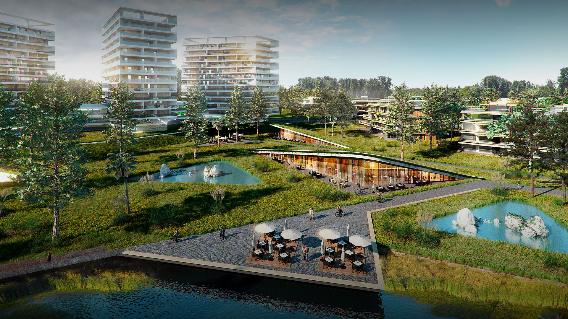
A smart city that connects nature, technology, and community
+Colonia proposes a natural expansion of the historic Uruguayan port city on land located one kilometer east of the passenger port. The 515 ha site has seven km of waterfront on the Río de la Plata. The project will allow the expansion of the eastern wing of the city over an area that for decades was a barrier to development on that front. The first stage would involve the development of almost 200 hectares.
The plan is to create an open community that offers a new relationship between nature and the city based on environmental sustainability, renewable energies and respect for the landscape. The proposed urban area is a platform for the development and generation of mixed and hyper-flexible programming experiences that will lead to an expansion of Colonia’s productive matrix. It aims at drawing new residents from Montevideo, Buenos Aires and other areas of the region. Once the various stages of the project have been completed, 7000 to 8000 new homes will be created.
It is planned to attract new settlers from Montevideo, Buenos Aires or other areas of the region. Once the various stages of the project are completed, between 7,000 and 8,000 new homes will be created.
Social diversity, outstanding educational centers and burgeoning businesses that generate employment are some of the components of the new city, which will be integrated into the existing urban area. This will help position Colonia as a regional innovation and knowledge hub capable of reconciling nature, heritage and modernity.


Urban Design Proposal
A polycentric cellular structure of alveolar nature is proposed, strongly permeated by the natural landscape at various scales, multiplying the qualified frontages of each development cluster. These urban units, surrounded and interconnected by nature, adapt to the specific characteristics of the site and are programmed according to demand, while also establishing a controlled growth strategy for the proper long-term management of the territory.
This cellular framework builds a network of highly distinctive public natural spaces, acknowledging major structuring events such as the Arroyo de la Caballada Park and the coastal edge along the river, while generating other intermediate thematic areas that enable multiple transversal connections across the site. This approach overcomes the frontal condition of the first riverfront row and unfolds value towards the interior of the territory. The new system of interstitial parks multiplies the “epidermis” of urban clusters, enhances diverse inland landscapes, and preserves the vitality of natural habitats and ecosystems.
The urban clusters incorporate the same generative logic, allowing for subdivision into smaller units through the extension of the green network towards the interior. Their polycentric nature allows for the combination of distinct expressive and programmatic identities within each cluster, reinforcing a unique and diverse experience.
The different clusters are “sustained” by being surrounded with significant natural landscape, adjusting their size and location to the geography. Proximity relations between them will enable the consolidation of shared thematic and programmatic polygons, structured around thematic parks.
The city–nature integration is linearly balanced across the site: from the “most urban” edge on the western sector—adjacent to the consolidated city—to the “most natural” condition on the eastern edge.
The primary road infrastructure network links the different clusters by connecting their centers. This consolidates two interwoven public-space systems: the system of natural parks and the system of primary urban roads. The development of each cluster will require a secondary public road network, to be defined according to the program of each component.
More than 50% of the master parcel will be allocated to the structure of parks, wetlands, and public-access waterfront. From the buildable land, an additional 20–30% will be reserved for the primary and secondary public road network.


