-
Program:
Urbanization
-
Status:
Concept and Schematic Design
-
Area:
411 ha
- Location:
-
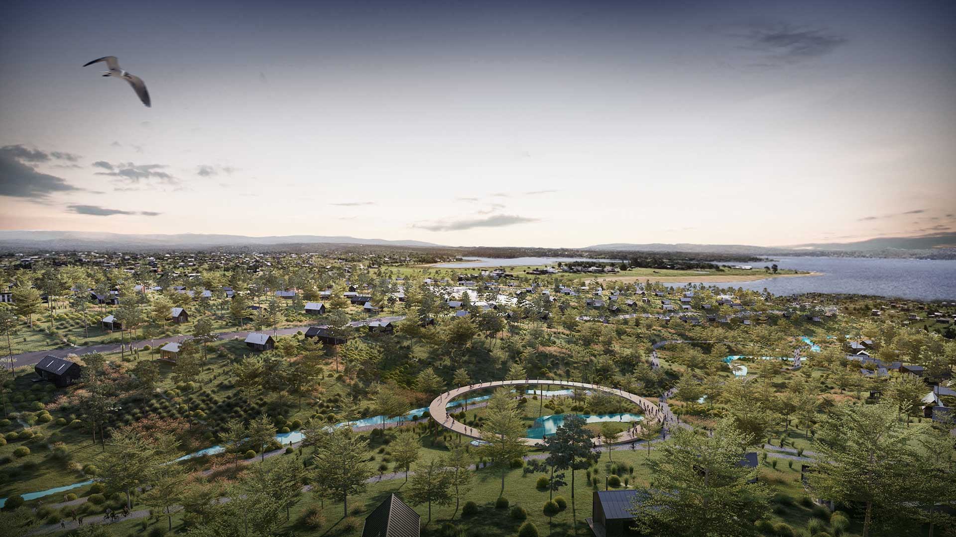
MP Potrero is a residential masterplan located on the urban edge of Potrero de Garay, in Córdoba, Argentina, within a transitional territory between the existing settlement and the landscape system associated with Lago Los Molinos.

The Potrero Garay urban concept organises a low- to medium-density residential fabric that integrates structure and landscape through a territorial strategy that understands the ground as both environmental and urban armature. The site is structured by Provincial Route S271, which divides the intervention area into distinct territorial pieces and defines the approach to access and connectivity. The urbanisation is conceived as a system that reconnects areas fragmented by the road alignment, incorporating roundabouts, hierarchised gateways, and a parkway avenue that links the different plot areas. This avenue operates as the masterplan’s principal spine and as the framework for the primary public realm, reinforcing continuity with the existing urban fabric. The central hub is positioned at the meeting point of local roads and routes, aligned with the edge of the most consolidated urban areas.
The project takes the sierras topography and the hydrological network as the ordering elements of the urban layout. Natural valleys and watercourses structure a continuous park system that organises the whole and channels surface runoff towards the main drainage corridor and the lake. Each residential sector is arranged as a territorial unit with its own servicing, connected to secondary parks that converge into larger, structuring green areas. This environmental system acts as green infrastructure, ensuring ecological continuity, hydrological regulation, and everyday public spaces, while establishing a gradual transition between the natural landscape and the built fabric.
Phase 1 anticipates the consolidation of a civic–commercial node, establishing the “pueblo” as the foundational piece of the masterplan. This sector anchors public life, forming a local-scale urban centre characteristic of Córdoba’s sierras landscape. The total area of the pueblo is approximately 58.85 ha, including 17.52 ha allocated to 207 residential plots and 17.01 ha corresponding to seven larger parcels for commercial uses and community amenities. The urban structure prioritises walkability, continuity of public space, and the interface between neighbourhood retail, places to dwell, and open views towards the lake. Green, sports and public-use areas make up a significant proportion of the sector, with 8.58 ha of green spaces, 4.88 ha of sports areas, and 10.84 ha allocated to the road and mobility network.


Phases 2 and 3 comprise the two residential neighbourhoods that complete the masterplan. El Pinar, located south of the central node, is developed in Phase 2 and proposes a higher-end residential fabric, with larger plots and a more direct relationship to the natural landscape. The system is completed by a nautical parcel and a public waterfront promenade along the water’s edge, expanding recreational use and reinforcing the project’s connection to the hydrological system.
Phase 3, Potrero Barrio, located north of the central hub, introduces a residential neighbourhood of comparatively lower density, in continuity with the existing settlement, with a more compact structure. Together, these residential sectors account for more than 220 ha, with a balanced distribution between private land, green areas, and the road network. This phasing sequence establishes a spatial and functional gradation that guides the development’s growth and consolidates a coherent, legible and flexible urban structure, capable of integrating with the territorial dynamics of the lake edge.
The masterplan incorporates complementary urban amenities, including a sports boulevard with courts and parks, and a commercial strip aligned with service streets and pedestrian routes. These operations address mobility, parking and dwell time by separating vehicular and pedestrian flows. MP Potrero is thus positioned as an integrated urbanisation proposal, where landscape, public realm and programme are articulated into a clear, adaptable territorial structure.


